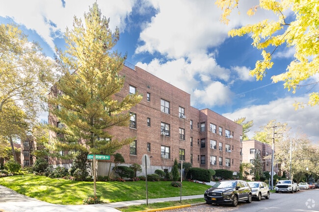
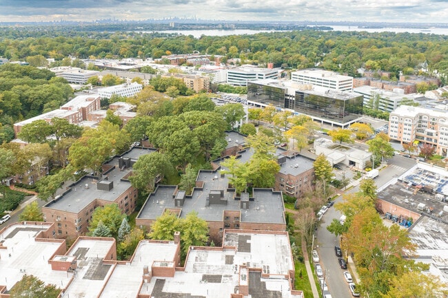
Property Record
48 Brompton Rd, Great Neck, NY 11021
NEARBY LISTINGS FOR SALE OR LEASE
Property Detail
48 Brompton Rd
2213-02-356-00-0003-0
3
Apartment
Nassau
X
New York
36059C0111G
3
2025
1.44 AC
2025
Great Neck Plaza
300700
Long Island (New York)
27,945 SF
Nassau County-Suffolk County, NY
DEMOGRAPHICS near 48 Brompton Rd
1 mile
3 mile
5 mile
2024 Total Population
26,891
148,461
520,982
2029 Population
26,743
142,909
495,846
Pop Growth 2024-2029
(0.55%)
(3.74%)
(4.82%)
Average Age
44
45
44
2024 Total Households
10,470
55,789
181,778
HH Growth 2024-2029
(0.51%)
(4.10%)
(5.17%)
Median Household Inc
$114,202
$110,159
$103,314
Avg Household Size
2.50
2.60
2.80
2024 Avg HH Vehicles
1.00
2.00
2.00
Median Home Value
$874,822
$860,101
$784,885
Median Year Built
1953
1957
1953
Nearby Places
Map Layers
Map Styles
 Street
 Aerial
Transit
 Traffic
 Biking
Places
Listings with unknown addresses are not visible on the map
- Restaurants
- Banks
- Shops
- Fitness
- Groceries
PUBLIC TRANSPORTATION
TRANSIT/SUBWAY
Great Neck Station (Port Washington Branch - Long Island Rail Road)
Drive
Walk
Distance
Great Neck Station (Port Washington Branch - Long Island Rail Road)
1 min
5 min
0.2 mi
COMMUTER RAIL
Great Neck Station (Port Washington Branch - Long Island Rail Road)
Drive
Walk
Distance
Great Neck Station (Port Washington Branch - Long Island Rail Road)
1 min
4 min
0.2 mi
Little Neck Station (Port Washington Branch - Long Island Rail Road)
Drive
Walk
Distance
Little Neck Station (Port Washington Branch - Long Island Rail Road)
5 min
1.8 mi
AIRPORT
LaGuardia
Drive
Walk
Distance
LaGuardia
21 min
11.6 mi
John F Kennedy International
Drive
Walk
Distance
John F Kennedy International
25 min
15.3 mi
Westchester County
Drive
Walk
Distance
Westchester County
49 min
30.9 mi
Freight Ports
NY - Red Hook Container Terminal
Drive
Walk
Distance
NY - Red Hook Container Terminal
32 min
19.7 mi
Nearby Properties
Address
Land Use
TOTAL SIZE
Lot Size
Zoning
Address
Land Use
TOTAL SIZE
Lot Size
Zoning
2,697,663 SF
3.46 AC
C5-3
Address
Land Use
TOTAL SIZE
Lot Size
Zoning
1,666,696 SF
1.87 AC
C52.5
Address
Land Use
TOTAL SIZE
Lot Size
Zoning
7,975 SF
133 AC
PARK
Address
Land Use
TOTAL SIZE
Lot Size
Zoning
97.07 AC
R3-2
Address
Land Use
TOTAL SIZE
Lot Size
Zoning
97.07 AC
R3-2
Address
Land Use
TOTAL SIZE
Lot Size
Zoning
97.07 AC
R3-2
Address
Land Use
TOTAL SIZE
Lot Size
Zoning
97.07 AC
R3-2
Address
Land Use
TOTAL SIZE
Lot Size
Zoning
97.07 AC
R3-2
Address
Land Use
TOTAL SIZE
Lot Size
Zoning
97.07 AC
R3-2
Address
Land Use
TOTAL SIZE
Lot Size
Zoning
97.07 AC
R3-2
Address
Land Use
TOTAL SIZE
Lot Size
Zoning
97.07 AC
R3-2
Address
Land Use
TOTAL SIZE
Lot Size
Zoning
97.07 AC
R3-2
Address
Land Use
TOTAL SIZE
Lot Size
Zoning
97.07 AC
R3-2
Address
Land Use
TOTAL SIZE
Lot Size
Zoning
97.07 AC
R3-2
Address
Land Use
TOTAL SIZE
Lot Size
Zoning
97.07 AC
R3-2
Address
Land Use
TOTAL SIZE
Lot Size
Zoning
97.07 AC
R3-2
Address
Land Use
TOTAL SIZE
Lot Size
Zoning
97.07 AC
R3-2
Address
Land Use
TOTAL SIZE
Lot Size
Zoning
97.07 AC
R3-2
Address
Land Use
TOTAL SIZE
Lot Size
Zoning
97.07 AC
R3-2
Address
Land Use
TOTAL SIZE
Lot Size
Zoning
97.07 AC
R3-2
Address
Land Use
TOTAL SIZE
Lot Size
Zoning
97.07 AC
R3-2
Address
Land Use
TOTAL SIZE
Lot Size
Zoning
97.07 AC
R3-2
Address
Land Use
TOTAL SIZE
Lot Size
Zoning
97.07 AC
R3-2
Address
Land Use
TOTAL SIZE
Lot Size
Zoning
97.07 AC
R3-2
Address
Land Use
TOTAL SIZE
Lot Size
Zoning
97.07 AC
R3-2
Address
Land Use
TOTAL SIZE
Lot Size
Zoning
97.07 AC
R3-2
Address
Land Use
TOTAL SIZE
Lot Size
Zoning
97.07 AC
R3-2
Address
Land Use
TOTAL SIZE
Lot Size
Zoning
97.07 AC
R3-2
Address
Land Use
TOTAL SIZE
Lot Size
Zoning
97.07 AC
R3-2
Address
Land Use
TOTAL SIZE
Lot Size
Zoning
97.07 AC
R3-2
The World's #1 Commercial Real Estate Marketplace
Connect with us
© 2026 CoStar Group
The information above has been obtained from sources believed reliable. While we do not doubt its accuracy we have not verified it and make no guarantee, warranty or representation about it. It is your responsibility to independently confirm its accuracy and completeness. Any projections, opinions, assumptions, or estimates used are for example only and do not represent the current or future performance of the property. The value of this transaction to you depends on tax and other factors which should be evaluated by your tax, financial, and legal advisors. You and your advisors should conduct a careful, independent investigation of the property to determine to your satisfaction the suitability of the property for your needs.